Showing posts with label scafell pike. Show all posts

Thursday, 30 May 2013

Scafell Pike Trail Marathon - High Terrain Events

19th May 2013. Scafell Pike Trail Marathon.
That would be a marathon (44km on the Garmin) involving 1800m of climb in total.
Starting at Portinscale and coinciding with the Keswick Mountain Festival. The world famous Liz and Alan from 9bar were there to look after us and keep us fueled up, also fellow 9bar runners Vicci and Shaun were already there getting set up. Big thanks to Ian and Emily from High Terrain Events for organizing a brilliant event I am sure will grow even more in popularity next time!

We set off at 8 or 8.30 I can't remember. After having a night in Grasmere at Thorney How (and a nice run around there the evening before) I was only a short drive away on the morning so even had a lie in until 5.30am!
 The route took runners on good trail down the western edge of Derwent Water for a few miles and eventually into Seatoller in Borrowdale. 

From there a short road section to Seathwaite and a water station where Liz and Ian were waiting. A quick gulp of water and I was off.


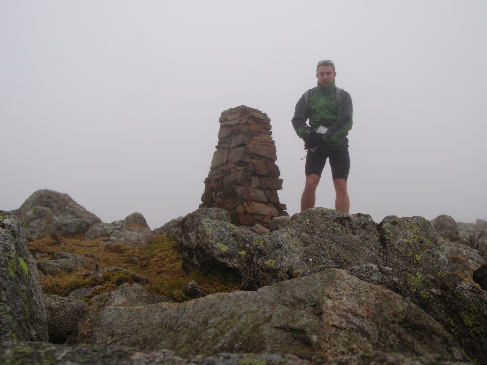
Now started the climbing heading up to Styhead Tarn where Stuart of Adventure in Mind was awaiting with our SI timing box. By now it we were in the low cloud and the ground was a little wet and slippery. A quick hello and swipe and off I went to find the Corridor route up Scafell Pike, in the cloud. It seemed to go on longer than I expected so grabbed the map out just to check and then within about 20m hit the path upwards.  

 A fairly long ascent, well one of the biggest in England I suppose? to reach Joe Faulkner of Nav4 at the summit of Scafell Pike. I didn't really stop to admire the view (pretty dense cloud) and made my way down to pick a route to Esk Hause (CP 3) It's a bit rough and rocky for a while after SCFP but then onto a nice descent to Esk Hause stone shelter which I found pretty straightforward before dibbing in my timing card and making a left towards Sprinkling tarn and back to Stuart at Styhead. As I was nearing the bottom a couple of runners were heading up towards me (had taken a wrong turn) who promptly spun around and went the way they were supposed to.


 Getting back to Styhead and swiping in before descending fairly quickly down to the water station and picking up the route along the eastern side of the lake heading to Watendlath (spelling?)  fairly quick going apart from the narrower sections where the runners doing the 13km and half marathon options were. Trying to swerve past them on single track required some shouting 'passing to the left' etc but most were fine. The odd one trying their best not to let me pass even though I was in a different race.

A bit of a climb (described as Kilimanjaro by my client Gilly - who did absolutely amazing in the 13km race! ;) ) followed by more nice undulating trail. I had run some of this part of the course before although not exactly and a quick glance at the Garmin suggesting about 3km to go which I immediately thought oh no long course! There was a final checkpoint somewhere in this section too.

Before I knew it I had hit the road leading to the finish which I had ran in the morning and settled at a good pace for the last 800m or so coming in 4.31 in the top 5! The field housing the finish area was possibly the muddiest slipperiest part of the day and finally got my shoes dirty after the finish line!


A brilliant run, not your ideal pb course if that's what you're into but had a wicked day!
On a clear day the scenery would be unbeatable like the organisation!

Thanks to 9bar, Stuart @ Adventure in Mind for a couple of the piccies and of course Ian and Emily at High Terrain Events!

Below... out in March on the Corridor route, not really ideal recce conditions as I didn't really recognize anything but great fun!


Tuesday, 28 February 2012

A quick assault on the Lake District 26 FEB

What better way to spend your Sunday morning than wolfing down a smoothie and popping up to the Lake District?! I arrived around 8am planning to do either option 1 a long section of the Lakeland 100mile race by getting a bus from Ambleside to Keswick and running back OR option 2 a bit of a BGR style recce. I arrived and noticed I had forgot to pack my compass so I parked up and searched pretty much every shop that was open at 8.30 on a Sunday morning, for a compass to no avail. I got a bit of food then noticed some of the staff in the shop below the climbing wall just arriving so I managed to get one from them before they opened properly! Thanks Guys! After that a quick feed and grabbed a bit more lunch to take with me and I headed over to Langdale opting for option 2 as I had now missed the bus to get to Keswick. 


Weather was reasonable in the valley but cloudy over the peaks. I hiked up to Stickle Tarn pretty rapidly passing a few groups of walkers and followed the tarn around to take a direct line up Sergeant Man, now in the clouds. Ground was quite wet with a few pockets of snow around. From here I followed a bearing for a small tarn not far from the top of High Raise, and then from there to the trig point on High Raise for a quick photo and to put my jacket on. From here the weather became more cloudy and some light rain, pretty windy in places but not too bad until it got dark. 
High Raise, the best weather I had really.


After HR I headed in the direction of Thunacar Knot on to Harrison Stickle before wolfing down a bit more food and a 9 bar and heading on to Pike of Stickle. I dashed across Martcrag Moor which was quite enjoyable long gradual descent with a few bogs and things to bounce through.After this I went around onto Rosset Pike enjoying some rock hopping on route. 


Tombstone like rock nr Rosset Pike
From there a quick trip around Angle Tarn and up to Ore Gap where I intended to divert to Bow Fell although I changed my mind and decided to leave it for the way home! Quite high up there was the occasional bit of snow around between Great End, Ill Crag, Broad Crag and the Scafells. A group of walkers were taking a direct route following the cairned path to Scafell Pike and I could here them talking somewhere within the blanket of cloud each time I diverted off to a peak they would pass, then as I headed for the next peak I would pass them, continuing in this fashion until somewhere before Scafell Pike. After Scafell pike I planned to head down in the direction of Wasdale then cut back up a steep line to Scafell. On descending a couple called me, I just managed to stop before them after a reasonably quick descent.
'Which way is down?' He asked.... It was clearly the opposite way to where they were going as they were pushing uphill.
Where are you going? I asked
'To the bottom, where the car park is, next to THE lake!'
I'm not being funny, but there are a lot of lakes being the Lake District do you know the name of it? I don't want to send you the wrong way!
After a look on his printed out map we figured it out and they carried on to 'the top' presumably Scafell Pike. Not very easy to find in cloud with no propper map or compass, always worth having one even on a clear day and knowing how to use it, just in case!

I headed down towards Wasdale to the wall that crosses the path near Lingmell Gill before cutting around Scafell heading southwards and then taking a pretty direct line upto Scafell. Didn't hang around too long as time was getting on I moved on to Foxes Tarn and followed the valley down with a good pace to the river Esk. My route took me up towards Esk Hause and it began to get dark pretty quick so out came the head torch. I headed back over Esk Pike towards Bowfell with the conditions worsening the wind was quite strong and although I was dry beneath my jacket, the weather wasn't getting any more pleasant! I decided to cut off and head down into the valley where conditions wouldn't be as bad and there was an easy trail to get back to Langdale as it was getting late and I had to be working at 6.30. Onto the Cumbria way which could accommodate a car I picked up a good pace and followed it all the way past the Old Dungeon Ghyll pub and back to my car. 

Before it got dark, looking towards river Esk


Totalled 2700m elevation, 40km and a good day out. Legs not really feeling any aches although I wasn't pushing the pace particularly hard. Good nav practice!
Pretty much best view all day!


Langdale, Stickle Tarn, Sergeant Man, High Raise, Thunacar Knot, Harrison Stickle, Pike of Stickle, Martcrag Moor, Buck Pike, Rosset Pike, Esk Pike, Great End, Ill Crag, Broad Crag, Scafell Pike, Scafell, Esk Hause, Angle Tarn, Langdale!